|
By Martin Merzer and Jennifer Babson. Mmerzer@herald.com.
Posted on Thu, Sep. 19, 2002 in
The Miami Herald.
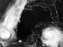
Hurricane Isidore, destined to commit considerable havoc, focused its wrath
on Cuba today. The first squalls arrived Thursday, and forecasters warned Cubans
to prepare for nearly three feet of rain, severe floods and damaging wind.
With the storm growing in size and intensity, forecasters took the
precaution of posting a tropical storm watch on the lower Florida Keys, south of
the Seven-Mile Bridge.
That means winds of at least 39 mph could sweep the area by Saturday. The
storm's outer gusts reached the Keys late Thursday. Forecasters predicted two to
four inches of rain and minor coastal flooding.
Officials considered canceling classes today in the Keys, but decided at 11
p.m. Thursday -- after receiving assurances that wind posed no danger to buses
-- to keep public schools open.
Ninety miles south, even with the core still approaching, Isidore's clouds
covered nearly all of Cuba late Thursday. Officials evacuated thousands of
children from low-lying agricultural areas, placed hospitals on alert and
drained dams in western provinces.
''Isidore will be spending Friday crossing the westernmost portion of
Cuba,'' said forecaster Lixion Avila of the National Hurricane Center in West
Miami-Dade County. "Thereafter, the forecast track becomes highly
uncertain.''
LOCAL FORECAST
Miami-Dade and Broward counties were very likely to avoid direct hits, but
experts expected Isidore to grow into a major hurricane by Saturday and come
close enough to produce rough seas, strong breezes and periods of heavy rain.
''It's us versus Mother Nature,'' said Irene Toner, director of Monroe
County's Emergency Operations Center in Marathon.
That was particularly true at the hurricane center, where forecasters
expressed extreme concern about Isidore's eventual strike at the mainland.
Computer programs predicted that Isidore would make landfall on the Gulf
Coast next week as an intense hurricane, but they could not agree on a spot or
even a state or country. The possibilities ranged from Florida's Big Bend to
Mexico's Yucatan Peninsula.
A consolidated image of the projected paths looked like a giant spider, its
legs splayed in nearly every direction.
Forecaster James Franklin sat motionless in front of that computerized image
Thursday, studying it for many minutes as if it contained a deeply hidden truth.
It did, but that truth could not be discerned, at least now.
''The atmosphere is so balanced that we're right on the edge,'' Franklin
said. "Just the slightest little push could make the difference.''
THE GULF AWAITS
Meanwhile, Isidore was expected to drift in the Gulf for days, feeding on
warm water, growing so large that it might fill the basin, generating high
swells and heavy rain.
It was predicted to become a major Category 3 hurricane, with wind of 120
mph by Saturday morning.
''The verdict is still out on where it will go,'' said Max Mayfield,
director of the hurricane center.
A greater degree of certainty materialized in Cuba, and none of it was good.
Forecasters warned of 30 inches of rain and storm surges 10 feet above
normal tides along Cuba's southern coast.
The center was predicted to pass close to the Isle of Youth early this
morning and hit the island's western tip around 9 a.m. -- as a Category 2
hurricane, with wind between 96 and 110 mph.
According to Cuban authorities, 43,000 schoolchildren and other residents of
imperiled areas were taken to shelters elsewhere. About 250 foreign tourists,
visiting the Bay of Pigs invasion site in southern Matanzas, returned to Havana.
Residents were advised to collect enough food and water for 10 days.
Twenty-three of 79 reservoirs in the western region were lowered.
Earlier, Isidore drenched Jamaica, where it caused severe flooding but no
reported deaths or injuries. It also knocked down trees and knocked out
electricity in parts of the Cayman Islands.
PREPARATIONS
With the storm predicted to linger in South Florida's meteorological
neighborhood for days, state and local officials began taking action.
Officials at Naval Air Facility Key West, which includes Boca Chica Naval
Air Field, carefully tracked Isidore.
''Right now, we have no plans to fly the jets out or the people, but we are
monitoring the thing closely,'' said Commander Pete Fyles, the facility's
executive officer.
Though the worst weather was expected to miss South Florida, local
forecasters remained alert for fringe effects like squalls, local flooding and
isolated tornadoes.
''It will be a close call, but that's what living in South Florida is all
about,'' said Rusty Pfost, in charge of the National Weather Service's South
Florida office.
"I'd rather have a close call than a direct hit.''
Herald staff writer Renato Pérez contributed to this report. |